By Meteorologist Joe Martucci
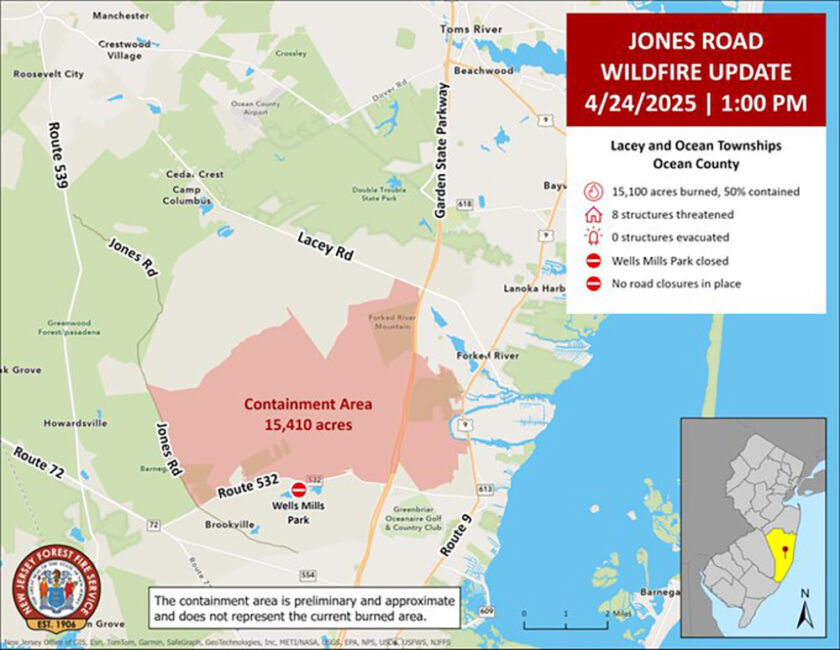
The Jones Road Fire, which was first spotted at 9:45 a.m. on April 22, was New Jersey’s largest wildfire in 18 years, swallowing up 23 square miles in Ocean County, or a little over 15,000 acres.
While drought conditions have improved across the area, the fire is a stark reminder that we are in the midst of a wildfire season that has big potential to be severe, if we are not careful.
The Pine Barrens is such a unique landscape that maybe we take it for granted. You learn about it in elementary school, and you might even be told about the Jersey Devil (whose home is in Galloway, according to legend).
In Meteorology School at Rutgers University, you learn the sandy soil makes it cool off quickly at night. Its composition makes it perfect for growing cranberries and blueberries. The forest is so dense, that satellite imagery shows this as a noticeably darker area than the rest of the state.
All that dense forest means one fire can spread quickly. Any forest that has dry ground with low humidity and a gusty wind can increase the size of the blaze. However, the New Jersey Pine Barrens, specifically, have a few factors that make this area uniquely prone to to fine.
Pitch pine
Pitch pine, which the region gets its Pine Barrens name from, is highly flammable. The needles and bark ignite easily.
Quickly drying soil
The sandy soil of the Pinelands, known as sugar soil to the locals, drains water quickly. Think of sand on the beach. You pour a bucket of water on it and a few minutes later, that wet spot pretty much dries out.
The same is true in the Pinelands. The ground dries out faster than most forests. The old adage that it will rain overnight, and you’ll have wildfire by noon is based on this truth. This year’s drought only amplifies that.
Topography and wind
The Pine Barrens in New Jersey are flat, like a big, open field. The trees there aren’t very tall, and their tops (called the canopy) have lots of gaps. This makes fires spread really fast.
Because the trees are shorter, wind from above can blow down to the ground where the fire is, without getting blocked like in other forests with taller trees.
Forest next to people
The Garden State Parkway is like a big boundary line in New Jersey. It separates the wild, state-protected Pinelands Area to the west from towns and cities to the east.
In Ocean County, starting at Toms River and going south, the west side of the Parkway is the Pinelands, while the east side has homes, stores, and businesses.
The Jones Road Fire happened in Ocean County. In Atlantic County, the Parkway separates the Pinelands from developed areas until about Mays Landing. In Cape May County, the Pinelands National Reserve follows the Parkway from Marmora down to around Swainton and Goshen.
You don’t have to go far from the Pinelands to find busy places! In Ocean County, right across the Parkway, there are huge neighborhoods with lots of houses. In Lacey Township and Ocean Township, where the Jones Road Fire burned, over 35,000 people live with homes, shops, and more, just a short distance from the forest.
Plus, you have to consider the Garden State Parkway running through there. In 2018, 389 million toll transactions took place on the road, according to NJ.com. When the Parkway closes, it backs up traffic and slows the local economy.
Last Tuesday, I had to go north, through the Jones Road Fire on the Parkway. I was diverted onto County Road 539 in Ocean County.
Thankfully, the traffic was moving north. However, going south on that one lane it was bumper-to-bumper traffic for miles. It’s an issue which could happen in the South Jersey shore area, too.
This drought plays a role
As of April 25, 662 wildfires have occurred in New Jersey this year – 16,572 acres burned, the vast majority of that the Jones Road Fire.
Last year through by April 25, about half as many wildfires occurred, burning just 315 acres.
The difference is drought. When the Jones Road Fire began, that area was in a transitionary state between drought and no drought, known as abnormally dry conditions, according to the United States Drought Monitor.
All of Atlantic and nearly all of Cape May counties were officially in drought. Plus, the New Jersey Department of Environmental Protection put forth a drought warning for the state in November.
Drought means, among other things, the ground is dry, and the water table is lower. This only enhanced the spread of wildfire.
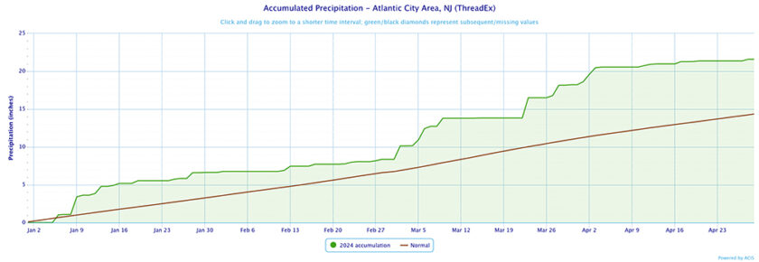
There has been no wetter-than-average month in 2025. Statewide, it was the third driest January on record, according to the Office of the New Jersey State Climatologist (0.92 inch average).
February was below average, too. March then bucked the trend, with nearly average precipitation. April should come in around the same (not known at the time of writing).
last year was nearly the opposite. It was the wettest start of the year, on record, through April 25, at Atlantic City International Airport, according to the National Oceanic and Atmospheric Administration. Located on the edge of the Pine Barrens, it’s a good indicator for the South Jersey Pinelands.
In Hammonton, farther into the Pine Barrens, it was the sixth wettest. Records have been kept fairly regularly since 1893.
As long as drought continues, and I believe it will in Atlantic and Cape May counties into the summer, the potential for another Jones Road Fire is higher than usual.
You can prevent wildfires
About 85% of wildfires in the United States are caused by humans, according to the United States Forest Service. Fire is a natural and needed part of our ecosystem. However, humans disrupt Mother Nature’s rhythm, which would typically happen from lightning strikes.
No published research has been done in New Jersey, but in California, researchers found that human-sparked wildfires spread more than twice as fast as lightning-induced burns, according to the University of California-Irvine.
What Smokey Bear first said in 1944 holds true in 2025, “Only you can prevent forest fires.”
Joe Martucci, a Certified Broadcast Meteorologist and Digital Meteorologist, is the President and Director of Meteorology for Cup A Joe Weather and Drone. You can connect with him at cupajoe.live.